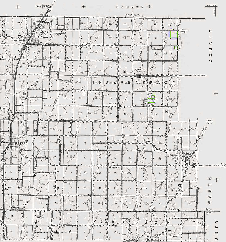
This is a section of a Nodaway County, Missouri Plat Map which is the
very northeast part of the county. You may want to download it and
then pull it up in your own choice of graphics program or you can open it in
a new window in your brower by clicking on the image. You will need to use your "back" button in your browser to return to this page.
A section is a one square mile track of land. A 'political' township
is different from a 'geographical' township. The political townships
are those that are given names. A geographical township is
a six square mile area consisting of 36 sections, and are number 1 through
36. Legal descriptions are based on the location of the land
from the meridians and parallels. Missouri is West of the 5th Principal
Meridian. Trying to describe the parallels is more difficult and
I won't get into that. Townships are designated either North or South
and Ranges are designated either East or West. When a Range states
that it is West, then it is describing it proximity to the closet Meridian,
being 'whatever the number' (ie 33) West of the 5th PM, then it would be
33 - six mile blocks West of the 5th PM. The same applies to the
Township, being its proximity to the closet parallel, either north of it
or south of it. But in legal descriptions, the reference to the specific
parallel is not mentioned and I don't know why.
ACRES - a section (one square mile) consists of 640 acres. A section
is divided into four quarters - the northeast, northwest, southeast and
southwest. Then each quarter can also be divided into quarters, and
so on. Each one-fourth of a section contains 160 acres. Half
of a quarter section would be 80 acres. A fourth of a quarter section
would be 40 acres. If a legal says the south half of the northeast
quarter, then in the section you would first find the northeast quarter,
then cut the section in half and you would have the south half of the northeast
quarter.
LEGAL DESCRIPTIONS ARE ALWAYS READ BACKWARDS
If you go to the very top right hand corner of the map below, you will
be able to see R34W|R33W along the top and then T67N|T66N just a little
ways down the right side. Staying in the very top right hand corner,
here is a simple legal description: The Northeast Quarter of Section
4, Township 66 North, Range 33 West. Did you figure it out?
Divide the section into four equal quarters - north and south line through
the center of the section and the east and west line through the center
of the section. They should cross right on the '4'. (north
being top of the page, south being bottom, east being right and west being
left) The Northeast Quarter is the top, right fourth of the section.
Here's another one. The Northeast Quarter of the Northeast Quarter
of Section 9, Township 66 North, Range 33 West.
Try another one. This one's a little more complicated. You'll
actually be looking for two tracks of land within the same legal description.
The Southeast Quarter of the Northwest Quarter, and the North Half of the
Southwest Quarter, all in Section 29, Township 66, Range 33.
If you happen to have a county plat book, sometimes called township
books, these will be broken down by 'political' townships. However,
they do give the township and ranges, and many political townships are
larger than 'geographical' townships, and some are smaller. A good
example of this is Maryville, Nodaway County, Missouri. Maryville
is located in Polk Township. Polk Township just happens to be 11
sections north to south and 11 sections east to west, making it much bigger
than the 'geographical' six section by six section township. Thus
the above legal descriptions are a part of the policital township of Independence
Township. In some policital Townships, there could be more than one
section with the same number, but the geographical Township and Range numbers,
section numbers only appear once.
Should you have a legal description that is given in degrees, minutes
and seconds, contact an abstracter or a surveyor.
