|
AVERAGE
ANNUAL PRODUCTION, 1901-1910 -- 95,945 TONS
Aside
from very small drifts and shallow shafts southwest of Browning, Linneus
and Laclede, mining has been confined to the southeastern part of Linn
county. There are shipping mines at Marceline and one is planned for
Bucklin: Several mines with large local trade operate near Brookfield.
Shafts were once sunk at St. Catherine. In spite of this rather small
development, the entire county is probably rich in coal deposits.
The formations exposed at the surface include the lower part of
the Pleasanton shales and sandstones, all of the Henrietta shales and
limestones, and that part of the Cherokee shale which lies above the
Tebo coal bed. Practically all these rocks are shown in the Bucklin
shaft record and most of them in the Brookfield and Marceline records, to
which the reader is referred for a general section. The higher coal beds
are not important in this area. There are basins of coal two feet or less
in thickness in the bottom of the Pleasanton formation, but the Lexington
and Summit horizons show no workable beds. The only coal at the Mulky
horizon is in rather small basins, such as the one south of St. Catherine.
The next lower coal is the Bevier, the one so extensively mined at Bevier
and elsewhere in Macon county.
Although this bed contains more than 3 feet of coal at Lingo, in Macon
county, at Bucklin it includes only 22 inches, at Marceline 18, at St.
Catherine 16, and at Brookfield 15. It has not been utilized in this
region. It is possible that it is thicker in some parts of the unexplored
portion of the county, especially the northeastern quarter. From 50
to 75 feet below the Bevier is the Tebo coal bed, the one worked at
all the principal mines. This bed is uniformly 26 to 30 inches thick
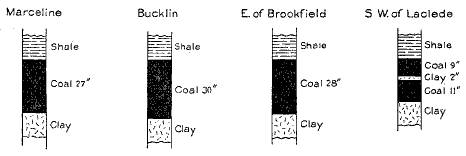
The Tebo
coal bed in Linn County.
in the southeastern quarter of the
county, but it is only 20 inches
thick in the southwestern. It is a good steam coal, though it contains
considerable "sulphur", and has a fairly stable shale roof. From
70 to
100 feet below the Tebo is a bed that has been explored only with the
drill. This is the Eureka, another bed with a shale roof. Where found
near Bucklin, Marceline, St. Catherine, and Brookfield, it is about 32
inches thick. In the St. Catherine record a three-foot coal bed was
struck 39 feet below the Eureka, though that is the only drilling in
which more than one bed was found below the Tebo. The top of the
Mississippian limestone, below which it is useless to search for coal,
was reached at 233 feet at Marceline and 294 feet at Brookfield. The
distance of the base of the Coal Measures below any given horizon
varies within limits from place to place, because of the uneven upper
surface of the Mississippian.
Broadly speaking, the strata dip gently to the south at an angle
equal to the slope of the main valleys. At and near Bucklin and
southwest of Browning the strata are slightly elevated by an arch, the
continuation of the College Mound anticline of Macon county, which
trends northwest-southeast. In the southwestern corner of the county
the beds are similarly elevated and are greatly disturbed, so that south
west of Laclede may be seen the lowest beds outcropping in the county.
Little is known about the amount of coal in the area north of the Bur-
lington railroad, as the more productive horizons are concealed beneath
the surface and practically no prospecting has been done with the drill. A
useful guide to prospectors is the fact that from the Sullivan county line
southward to the railroad, except at a few places, the horizon of the
Summit coal lies close to the level of Locust, East Yellow, and West
Yellow creeks. The distance from the Summit to the first important coal
horizon, the Bevier, is about 50 feet, so that the distance to it and
lower productive horizons may be roughly estimated in any locality in
northern Linn county, provided the elevations of the main creeks and the
tract to be drilled are known.
The aggregate thickness of the coal found in the Coal Measures
at Brookfield, St. Catherine, Bucklin, and Marceline, in beds 14 inches
or more thick averages 86 inches, but some of the beds thin to the west
and northwest; the lower ones lie in large basins only, and under certain
areas near lower Locust creek there is little or no coal. The following
table is made on the assumption that the beds contain 1800
tons to the acre-foot:
TOTAL ORIGINAL TONNAGE OF COAL IN LINN COUNTY.
Average Area
thickness in Content of beds
of beds square in
in inches. miles. tons.
Southeastern quarter ........................ 86 155 1,279,680,000
Southwestern quarter ....................... 24 155 357,120,000
Northern half ............................. 40 310 1,190,400,000
Totals ............................................. 620 2,827,200,000
DETAILED
MENTION
Marceline.-Marceline
owes its prosperity largely to the coal-
mining industry that has flourished there for many years, the Tebo
bed being the one mined. There are now two large shipping mines
with short spurs from the Santa Fe railroad, both operated by the
Marceline Coal and Mining Co., and one local mine operated by the
Landreth Coal Co. All mines have steam hoists and other modern
equipment. Much of the product not sold locally is utilized by the
railroad.
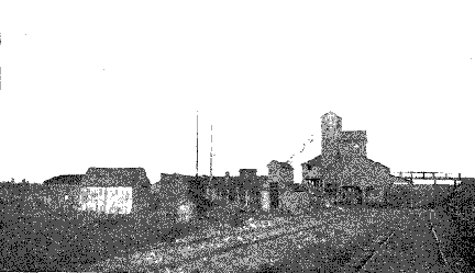
Mine
# 1 - Marceline Coal & Mining Co., Marceline
Mine
No. 1 of the Marceline Coal and Mining Co. is 190 feet
deep and is in the southeastern corner of the city, near the Chariton
county line (S. E. 1/4 S. W. 1/4 Sec. 32, T. 57 N., R. 18 W.).
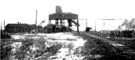
Mine
# 2 - Marceline Coal & Mining Co., Marceline
Mine
No. 2 is 130 feet deep and is just outside the city limits, 1 1/4 miles
north of the depot. It is notable that the coal at the Landreth mine is
about 40 feet higher in elevation than that at the shipping mines,
indicating a strong dip. In the Landreth mine the dip is southeast; in No.
1 the dip is regularly 1 ½ per cent to the south; in No. 2 the dips are
very irregular in the south workings and in places cause 10 per cent
grades.
The bed mined is fairly regular at 27 inches in mine No. 1; at the
Landreth mine it is 24 to 32 inches; at mine No. 2 it is very
irregular, being 25 to 42 inches at the present working face. Variation in
thickness is greatest where the coal is thickest. "Horsebacks"
in
the underclay and "rolls" in the roof decrease the thickness
locally. The quality of the bed is not of the best. Though it makes a good
steam
coal, it contains considerable sulphur in streaks of iron pyrites and in
large lenticles of pyrite combined with shaly and calcareous material.
The greater part of these impurities is picked out and discarded;
some pyritiferous chunks weighing more than 100 pounds were seen
on the dumps.
All the mines employ the longwall system. The roof is a drab,
slightly sandy shale that makes a good longwall roof, though it will
not stand machine mining and must be rather closely timbered on the
main roads. In mine No. 2 there are two plies of draw shale aggregating in
thickness about one foot; in No. 1 only one ply of 3 inches comes down
with the coal. Under the coal is a thick clay containing numerous
limestone boulders of various sizes. Locally these boulders may lie so
close to the coal as to make it necessary to do the undermining in the
coal itself. Where there is much rock and the top of
the concretions forms a fairly even surface, like that of a regular
limestone stratum, what is termed "rock bottom" is formed. The
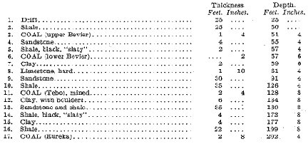
rocks found in the Marceline district above the Tebo coal are well shown
in the following record furnished by the superintendent of the Marceline
Coal and Mining Co.:
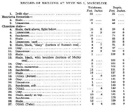
The
following record furnished by Mr. Landreth includes the strata penetrated
by his shaft and a generalized section of lower strata found by drilling
in various parts of the district. The shaft section
differs from the drill record at mine No. 1 chiefly in the detail of the
Bevier bed and in the greater distance assigned to the interval between
it and the Tebo:
LANDRETH
SHAFT RECORD AND DRILLINGS, MARCELINE.
Thickness. Depth.
Feet. Inches. Feet. Inches.
The
gas drilling at Marceline, which was carried to a depth of
2004 feet, was bored near and at about the same level as the Landreth
shaft. According to the record, the Mississippian limestone, the lower
limit of coal, was reached at 233 feet, about 110 feet below the Tebo
horizon. Little except shale was found in the lower part of the Coal
Measures.
Bucklin.-Recently
a single-compartment shaft was sunk 230 feet
near the Burlington railroad, a short distance west of the Santa Fe
crossing at Bucklin. The Tebo bed is being mined by a co-operative
company of citizens and has proved so satisfactory that a larger shaft
is to be sunk and direct connections made with both railroads. The
coal is 28 to 32 inches, very hard and
fairly clean. The roof is a dark
drab shale that stands well with the longwall plan of mining pursued:
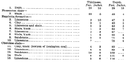
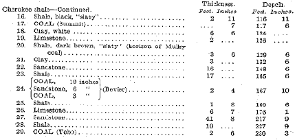
RECORD
OF BUCKLIN SHAFT
Thickness. Depth.
Feet. Inches. Feet. Inches.
It
is reported that the same amount of coal was found by drilling
at points about a mile east and southeast of town and that 32 inches
of coal (Eureka) was struck 70 feet below the Tebo. The strata dip
slightly east, west, and south from Bucklin, showing that the axis of
the anticline, or arch, mentioned in the report on Macon county as
passing south of Lingo, trends northwest-southeast through Bucklin
or its vicinity. The Tebo bed is about 25 feet higher at Bucklin than
at Lingo or Marceline, and 40 feet higher than at Brookfield. North
of Bucklin there is a slight southerly dip as far as the Sullivan county
line.
St. Catherine.-More than thirty years ago mines were operated
at St. Catherine, half way between Bucklin and Brookfield, the last
worked (S. W. 1/4 Sec. 35, T. 58 N., R. 19 W.) being 140 feet deep, and an
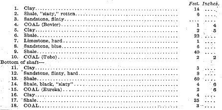
older one near it 90 feet. The following record cited by Broadhead shows
several workable beds:
ST.
CATHERINE SHAFT AND BORE.
Feet. Inches.
Two
miles south of St. Catherine (N. W. 1/4 S. W. 1/4 Sec. 12, T. 57 N., R. 19
W.) is the drift of S. Rosenthal in coal 18 to 24 inches thick, with a
roof consisting of four feet of black "slaty" shale bearing
large concretions ("niggerheads") and capped with five feet of
drab to buff limestone. This coal is the Mulky bed, and it is only in this
vicinity that it is known to be of workable thickness in southern Linn
county. It is said that a short distance south the concretions cut down
badly into the coal. The Summit coal is too thin to be utilized but is of
importance as a marker for lower horizons. Near the railroad it is 25 feet
above East Yellow creek, and two miles farther north it is at the water
level. North of this it rises at about the gradient of the creek, keeping
near
the stream.
Brookfield.-Several
attempts to obtain coal by shafting have been made on the west side of
Yellow creek near Brookfield, but all have been unsuccessful because of
the amount of water encountered and because the Tebo bed contains more
impurities than farther east. One mine formerly operated at the east city
limits reached at 155 feet the Tebo bed, consisting of 26 inches of coal
divided in the center by
three inches of shale that is said to thicken to the west. On the east
side of Yellow creek, about 1 1/2 miles east of Brookfield, is a group of
mines that now supply fuel to the city. All hoist with horse-whims, have
no shipping connections, and work longwall. The bed mined is the Tebo,
which contains 24 to 32 inches of coal with a very thin streak of
carbonaceous clay in the center. Iron pyrites ("sulphur") is
fairly plentiful, and in places rolls in the roof cut out half the coal or
less. Mines in operation in 1910 were:
(1)
H. D. Burdall (N. E. 1/4 N. E. 1/4 Sec. 5, T. 57 N., R. 19 W.), shaft 140
feet;
(2)
H. F. Wine (S. W. 1/4 S. W. 1/4 Sec. 33, T. 58 N., R. 19 W.), shaft 151
feet;
(3)
J. Turpin (S. W. 1/4 N. W. 1/4 Sec. 4, T. 57 N., R. 19 W.), shaft 138
feet;
(4)
Crandall brothers (N. W. 1/4 N. E. 14 Sec. 9, T. 57 N., R. 19 W.), shaft
155 feet;
(5)
Walker and Scott (Sec. 16, T. 57 N., R. 19 W.), shaft 160 feet.
There is a thinner coal bed above the one worked and a slightly
thicker one of doubtful quality below.
The
Summit coal bed, which is about six inches thick and lies
about 120 feet above the Tebo horizon, outcrops in the bank of West
Yellow creek near the railroad bridge. It forms a useful marker and
is characterized by a cap-rock of compact gray limestone that weathers
into rhomboidal slabs and is separated from the coal by about three feet
of black "slaty" shale. The Summit outcrops near the level of
West Yellow creek five miles northeast of Brookfield (S. W. 1/4 S. W. 1/4
Sec. 10, T. 58 N., R. 19 W.) showing a slight rise of the strata toward
the north.
Laclede.-Attempts to find coal at Laclede have not been successful. A
drilling for water to a depth of 248 feet in the north part of town was
barren of coal. Another, two miles southwest, found nothing over six
inches thick in 137 feet, and one on Coal branch, only 1 1/4 miles north
of the mining locality mentioned below, gave no results in 127 feet. The
lack of coal at these localities may possibly be connected with the
presence of a sandstone-filled channel known to exist about three miles
southwest of Laclede, in which case more productive territory may lay
quite close to barren drillings. At Woodland Mills (N. E. 1/4 Sec. 14, T.
57 N., R. 21 W.) there is a remarkable exposure in the bluffs of Locust
creek, where strata geologically higher than any seen elsewhere in
southwestern Linn county dip steeply down stream and are overlain
unconformably with sandstone and shales similar to those described as the
Moberly channel deposits in Chariton, Randolph, and other counties.
One mile southeast of Woodland Mills (N. 1/2 Sec. 24, T. 57 N.,
R. 21 W.) small drifts and shallow shafts have been worked intermittently
for years. The bed mined is the Tebo, the same as the one worked at
Brookfield and at the Turkey creek mine in Chariton county, but its
elevation is considerably higher than in the former field. It probably
underlies a considerable territory in this part of the county, though cut
off on the north by sandstone. The coal is 20 inches thick, with two
inches of clay in the center. Above it is 56 inches of blue shale, above
which is two feet of black shale capped with one foot of limestone. Below
the coal is four feet of blue and yellow clay resting on sandstone.
Meadville.-It
is reported that on a hill in the eastern part of Meadville a shaft was
sunk 120 feet without finding coal. A shaft 100 feet deep reached 18
inches of coal about a mile northwest of town. On Locust creek, east of
Meadville (Secs. 27 and 34, T. 58 N., R. 21 W.), a little mining has been
done in 17 inches of coal that lies 20 feet above the creek. Above the
coal is 20 feet or more of sandy shale. Below a parting of bituminous
shale more than one foot thick is a lower bench of coal six inches thick
and below this 15 feet of clay containing calcareous concretions and
resting on a hard blue limestone that outcrops in the creek. The
association of strata resembles that at the Bevier horizon, but such a
correlation can be made only tentatively.
Linneus.-Beds
outcropping near Linneus lie too high in the series to bear much workable
coal, but indicate the depth at which the more important horizons may be
reached. Just north of the city (Sec. 31, T. 59 N., R. 20 W.) are 15 feet
of red shales lying near the base of the Pleasanton, the same as the
highest rocks in the Bucklin shaft record. Descending to the west from
this locality the rocks of the Henrietta formation may be seen, and in
Locust creek (Sec. 34, T. 59 N., R. 21 W.) those just above and below the
Summit coal horizon outcrop, the coal itself being represented only by
black "slaty" (laminated) shale.
Three miles north the place from the outcrop of the Summit coal is 20 feet
above Locust creek, with a mere streak of coal exposed at the Mulky
horizon below it. This dip to the south nearly equal to the gradient of
the creek continues for a considerable distance up stream, so that west of
Purdin (S. W. 1/4 N. W. 1/4 Sec. 11, T. 59 N., R. 21 W.) the "slaty"
shale of the Summit horizon may again be found about 25 feet above Locust
creek, and farther north (N. W. 1/4 N. E. 1/4 Sec. 2, T. 59 N., R. 21 W.)
it is at the water level.
Browning.-Rumors
of two to four feet of coal found in a drilling near Browning are
persistent, though nothing definite could be ascertained. The principal
coal horizons lie 130 feet or more below the town, as the outcropping
strata in the vicinity are Pleasanton shales and sandstones. One mile west
of Browning (N. E. 1/4 N. W. 1/4 Sec. 7, T. 60 N., R. 20 W.) a bed that
lies in the Pleasanton and is only eight inches thick has been stripped a
little, and west of this, on West Locust creek, the limestone a few feet
below the top of the Cherokee formation outcrops. A short distance down
stream (N. W. 1/4 N. W. ¼ Sec. 14, T. 60 N., R. 21 W.) is a coal bed
reported to be 14 inches thick, but not now exposed. Four miles southwest
of Browning an arch, or anticline, brings above Locust creek rocks which
are, according to F. C. Greene, stratigraphically lower than those
outcropping elsewhere in northern Linn county.
|


